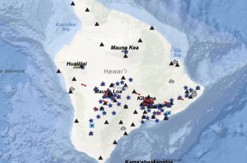
Mauna Loa, the world’s largest active volcano and one of the most active, is in the midst of its latest eruption, the first since 1984. The volcano is located in Hawai’i, on the “Big Island” of Hawai’i – in fact, it makes up the majority of the “Big Island’s” landmass, covering about half of the island.
Though geologists have learned that most output from Mauna Loa is non-explosive and tends toward more fluid lava flows, the current risk level is considered “Very High,” according to the U.S. Geological Survey, which has manned observation points and laboratories around Mauna Loa. The Guardian reports that more than 200,000 residents nearby have been warned to prepare for evacuation, should the flows begin to move in their direction.

Yet lava flows and potential property damage are not the only threat to Hawai’ian residents. The National Weather Service’s Honolulu page warns about “vog,” volcanic air pollution that contains dangerous components, and how to protect against this threat.
It is important to remember that vog can cause respiratory issues for certain individuals. Here are some resources to follow the concentrations of vog. https://t.co/Pv9ppIpBZEhttps://t.co/YzEiAYZx56 pic.twitter.com/7qDfzPeCqh
— NWSHonolulu (@NWSHonolulu) November 29, 2022
The eruption began on November 27 and continues to be active. The USGS relates that Mauna Loa has erupted 33 times since its first documented (by Westerners) eruption in 1843, and it is in the “shield-building” stage, meaning that it is rapidly growing and adding to its overall size.
https://twitter.com/USGSVolcanoes/status/1597976019851427843?s=20&t=1uzsjFyAlPjuwCdstmgO7w
From Nov. 27 through today, Mauna Loa has been mentioned 127.4K times across platforms, with a surge on Nov. 28, when the news of the eruption broke in the continental U.S. The eruption began around 11:30 p.m. HST on Nov. 27, and prior to that time most of the content surrounding the volcano discussed weather and natural conditions – from the volcano beginning to rumble to even a winter weather alert atop the peak.
One of the top trends of dialogue is “rift zone,” noting the location of some of the volcanic fissures, with others wondering if this eruption is indicative of more increased activity around the Pacific’s famed “Ring of Fire.” However, the USGS reassures us that activity is normal, at least along the continental U.S.’s west coast:
https://twitter.com/USGSVolcanoes/status/1598007162831179776?s=20&t=1uzsjFyAlPjuwCdstmgO7w
While at this point it looks like the eruption will not account for any damage or loss of life due to the lava flows, it remains to be seen how the ash and “vog” will affect residents and other Pacific islanders. A carbon monitoring bot on Twitter indicates that carbon levels around Mauna Loa are consistently higher this year than past years, even without the eruption factoring in.
Average CO2 at Mauna Loa, Hawaii
Today: 417.31
1 Year Ago: 415.33
10 Years Ago: 393.31 pic.twitter.com/shwVAnobjP— CarbonBot (@BotCarbon) November 30, 2022
And for those of us who aren’t under immediate threat from the eruption, the videos and photos are truly awe-inspiring and a reminder of the sheer power of our planet’s geological forces. Reuters has shared a video of the eruption from a helicopter service on the island, and many other social media users have shared the video straight from the company itself:
Update on the Mauna Loa eruption 11/29 7:26am #MaunaLoa #MaunaLoaErupts #volcano #hawaii #paradisehelicopters pic.twitter.com/yF9tL3ORll
— Paradise Helicopters (@Paradisecopters) November 29, 2022
Author: Kayleigh Jackson
